

Apk Link: https://cdn.organicmaps.app/apk/OrganicMaps-24081605-GooglePlay.apk
Note: If you don’t want to deal with stuff like this, I recommend you download and use it from F-Droid client or Accrescent AppStore.
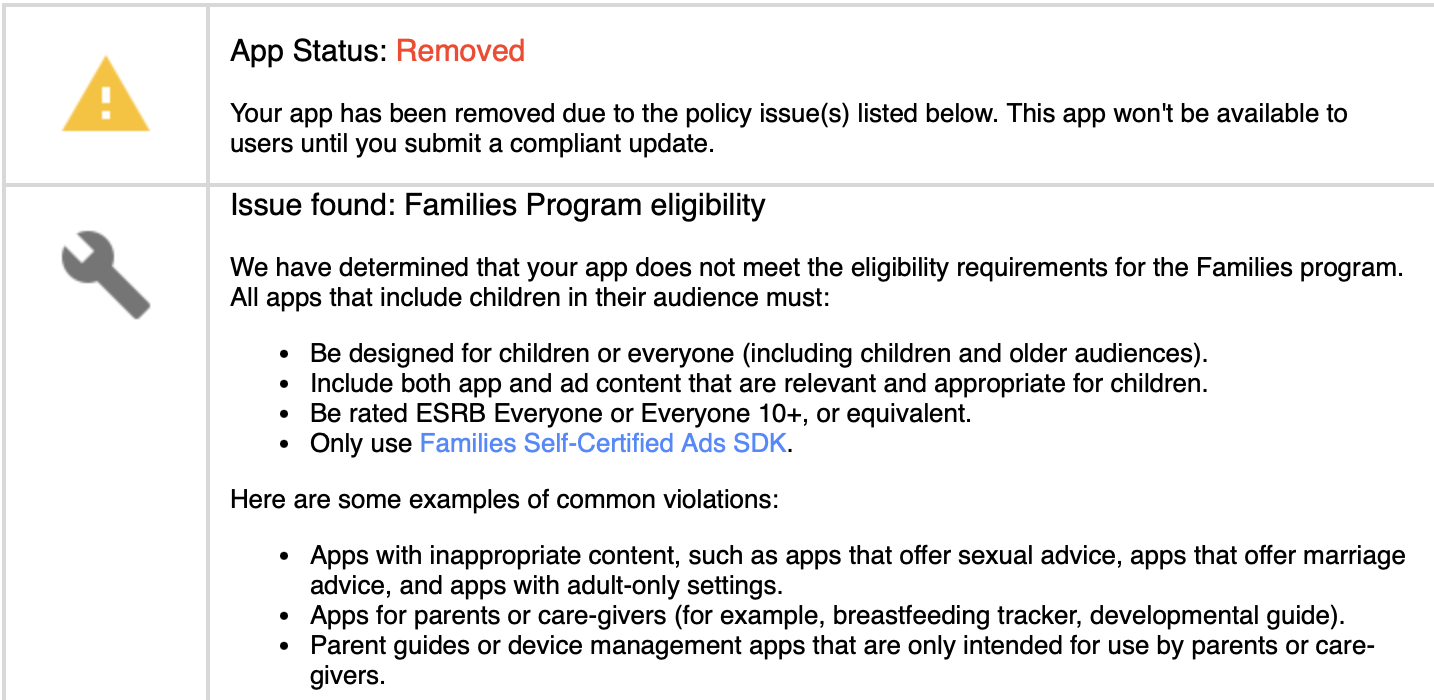
Update: The app returned to the App Store.
deleted by creator
I don’t know if Google has some API to indicate when the app runs from a child/family link managed account?
If so, then I suppose the Organic Maps dev could block some building categories from showing up (ex: Bars, Stripclub)?
“I love looking at the 3D building of this place. I am about to ejaculate in my pants”
Some buildings may be too sexy!
The app showed me a skyscraper and now I feel inadequate.
All buildings are beautiful!
That would mean EVERY map app would be in violation since those places exist and are indexed by all of them. Including Google Maps.
Are those apps available through the Families program as safe for kids?
No idea, is Google Maps listed as being safe for kids? It even has a default built-in search option to find nearby bars.
Either way, they removed the app from the entire Play Store, not just from kids accounts, or family sharing. Google specifically has as a separate account type for kids, ostensibly for the exact scenario they seem to be claiming is the reason for the removal here.
You really trust a company(google) who warns users about malware from apks(non-google)… and then hosts plenty of unchecked malware in their own store. Im sick of this shit. I have my own friends distrusting me because of what google is telling them.
deleted by creator
No… Google maps even has a quick search for bars built in.
Long shot, but does anyone know of any mapping app where you can easily project a bearing/azimuth line, or a point a given bearing and distance from another point?
The only app I’ve found so far that can come close to what I need is Backcountry Navigator, which has a terrible UI. Everything else seems to be focused entirely on GPS navigation from where you are now to a known destination; I have yet to find one that allows even basic triangulation, to be able to identify the location of an observed object.
deleted by creator
ATAK-Civ originally developed by the U.S. Military for tactical use on Android phones. It was open-sourced and released on the Play Store several years ago.
Wow.
That’s… Awesome.
Edit: That has pretty much every major feature I’ve been looking for.
Probably because of NSFW geographic locations, like https://omaps.app/U4yUt5ZjzL/Püssi
Organic Maps should be 18+.
That place exists in Google Maps too.
Google Maps are such hippocrates! 😆
It exists in real life too
Really? I heard that’s the most kid friendly place on earth.
Hmmmm. Just when I posted about Organic Maps on Lemmy. Coincidence?
Yes.
Alright
Problem is the FDroid version doesn’t work with Android Auto iirc

The amount of corporate control that has slowly and insidiously crept into our lives will never cease to amaze me.
Google is corrupt
Capitalism baby. Gotta cannibalize, monopolize, and enshittifize for maximum profits.
giggles in F-Droid
“Ooh rah”
Use Obtainium, Add App, paste this URL… https://github.com/organicmaps/organicmaps
No Play store or Fdroid BS.
Yes but three is no android auto with this way
Thanks, uninstalled from app store and did this instead.
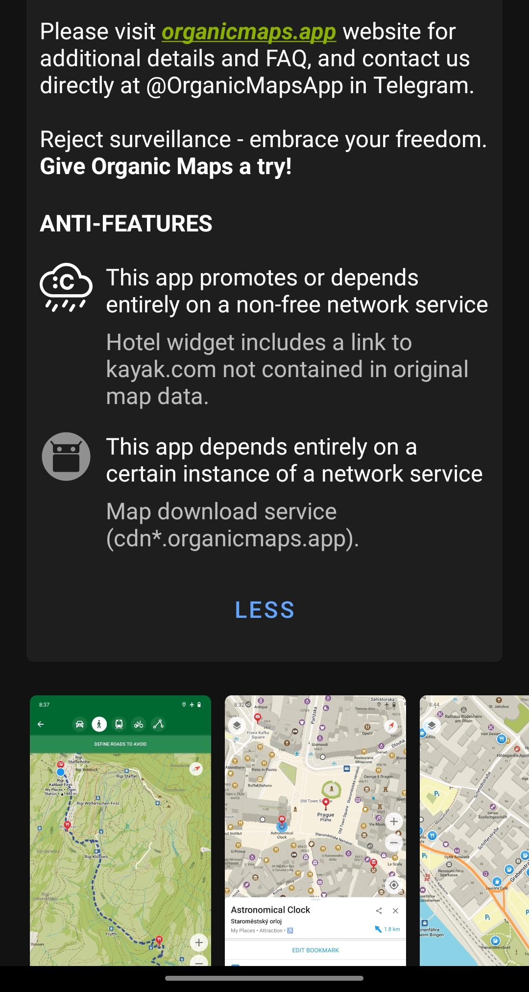
I like f droid and currently using droidify. On f-droid you have to enable “anti-features” and it’s not a bad feature in my opinion. It discloses if it’s using non free services.
Not showing up in my f-droid either
deleted by creator
Thanks, I had to allow other anti features.
Same for me, I had to enable Other-antifeatures in F-droid settings.
Thanks, enabling anti-fearures worked.
Yet another reminder that Google is an unreliable company. Install Fdroid tonavoid Google’s mistakes.
@ModerateImprovement @istanbullu F-Droid is the only way out.
deleted by creator
Thx for.the post. Just installed via fdroid. Awesome app.
Maybe it was a mix up? I just checked their website and clicked on the link they had for playstore and then downloaded it from there.
deleted by creator
TIL, I never knew this existed. Currently downloading it. Any other suggestions for someone in iOS (openmaps related)?
Go Map!! for editing the map
I’ll look into it
This app is great. If it offered some sort of traffic aware navigation routing I would use it as my daily driver. I live in the city and traffic conditions can make a huge difference. Unfortunately, I don’t think it has this capability. Hopefully someday.
The problem with live traffic awareness is, that it needs a lot of data to be collected all the time, something only Google or Apple with their monopolistic and privacy invasive ppwer can do. How it works (simplified) is that Google can detect if a lot of phones are on the same street and therefore assumes traffic. This data is, however, proprietary to Google. A FOSS App has the following problems:
- Too small of a userbase, to reliably track something
- Privacy conscious userbase, not wanting to be tracked
- If it had auch a feature, it would be opt-in, as FOSS does (usually) not try to be as evil as Google&Co.
- Usually limited server capacity to calculate if an aggregation is traffic
Solutions would be:
- Google is forced to make the data publicly available per API as part of some anti-monopolistic ruling
- A thrid party (e.g. cities) have their own monitoring of traffic and give public access to it.
So sadly similar dunctionality will not come in the near future in any FOSS app.
I’d be willing to share anonymized data as part of a collective traffic data alternative to Google. I imagine there would still be data fees associated with this data collection. We just really need to get an open source alternative to gmaps going. Gmaps is only getting worse. Like, what if something like Street Complete was also able to collect traffic data and feed it into a sharable database?
Alternatively, I wonder if they could buy traffic data from a third party like Garmin or something. I’d be willing to pay a small monthly fee to get away from Google.
Waze was able to do it (before Google bought them).
Waze still does it.
The data pulled in by Waze is independent from the data pulled in by Google Maps.
Waze doesn’t use Google’s traffic data, but Google does read data out of Waze’s.
Yet somehow Waze still has more accurate real time traffic info in the app.
Magic Earth has traffic. That’s the reason why I use it instead of Organic Maps.
I have looked at the routing on routes I regularly drive and it seems like Magic Earth has a better routing algorithm than Organic Maps. At least it doesn’t try to send me through the middle of a town when there is a route around the town using the highway as Organic Maps often tries to do.


