
You must log in or register to comment.
deleted by creator
Kansas City just got shit on
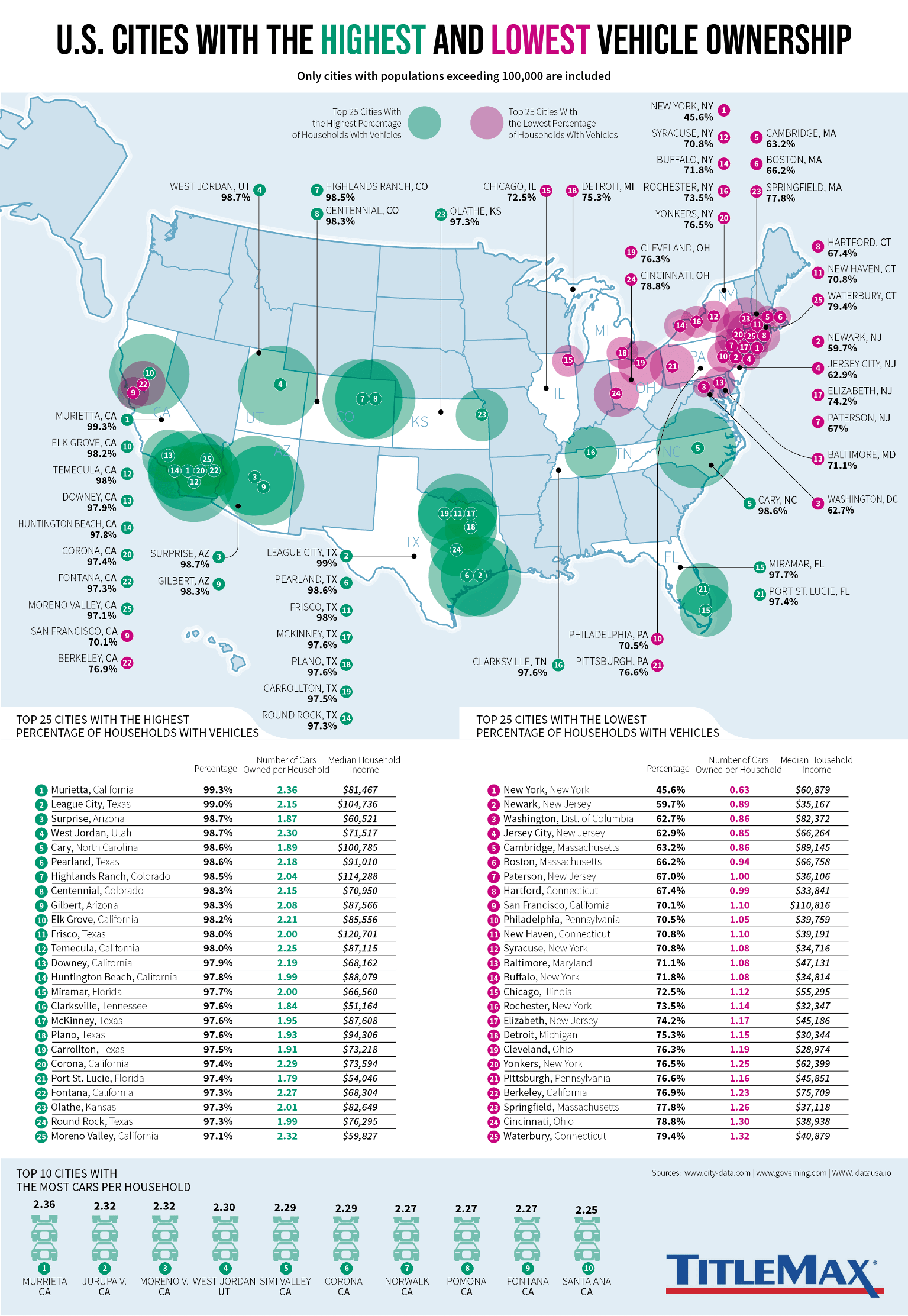
IE cities being in the top 25 is unsurprising but Murietta being #1 is wild. Totally makes sense tho if anyone has been in that area
The title could be cities with good vs bad city planning. All the green cities are designed to force people to use cars, because they made everything so spread out with little to no public transportation. The red cities are built properly with public transportation to help people get around.
Have you been to Los Angeles? It’s not so much that it was poorly designed as it is that it just never stopped growing. Los Angeles county is 4753 square miles.
Yeah, I went on a road trip a long time ago. I remember it was almost all highway with tons of cars without a good public transport system. They knew they were growing and could have held off the heavy traffic with commuter trains and a substantial public transport system.
Sure there’s a system already in place in LA, though I’m sure there’s room for improvement.
Or bad vs worse city planning. I was surprised to see so many upstate NY cities on the low car ownership list. They do have some public transport but can still be pretty tough without a car. Though they’ve all had some efforts to rein in some failed urban renewal projects like bulldozing unnecessary freeways, and some attempts at improving walking and biking experiences.
I imagine that it has to do with the age of those cities. They were established before cars, so the older parts were designed to get around easier. At least that’s what I assume, because virtually all the cities with low car ownership are in New England.
In conclusion, North California is a land of contrasts
deleted by creator
Knowing the actual public transportation options here its pretty sad. They are expanding bus services but getting around the city requires either a bike or a car.
deleted by creator
Property has stayed relatively cheap around here. So people working service jobs can afford to live closer to work sometimes. But I think the answer is a combination of unemployment, inability to afford a car and people driving without license and registration which is used for this data explains it more than a functioning public transportation system.
How much trouble does winter weather cause for folks in Detroit who do not have cars? How close to downtown Detroit do you need to be to still have an acceptable amount of freedom of movement without needing a car?
From personal experience living in Denver (we get roughly the same snowfall as Detroit). I found driving in the snow much more annoying then walking/taking the bus.
I’m guessing Detroit’s lack of car ownership is partly due to income.
Makes sense for AZ. It takes about 3hrs to drive from Queen Creek to Buckeye (that’s going east to west in Phoenix). And neither of those suburbs/towns have bus routes. Farthest east you can take the bus is Chandler/Mesa and the farthest west is Avondale, you’re still 30-45min away from Queen Creek and about 15 from Buckeye. The farthest north is Peoria which is still the inner city, not sure about south because no one goes to south Phoenix lmao (iykyk).
And it’s hotter than hell in Phx. Even if you can take the bus, waiting for a bus when it’s 110 is less than ideal, as is walking to or from the bus stop with groceries. I’m surprised Phoenix and all its suburbs weren’t on this list, especially given how spread out everything is in Phx.
The biggest reson for this is probably area density…the areas with fewest cars per capita are the places where things are geographically condensed,which makes public transport a viable alternative. Most southern cities are simply too spread out for public trans to be economically viable, and so having more vehicles is more pertinent.
While density is helpful ,US suburbs can support great transit for less than the cost of their cars. However they can’t support bad transit, or even okay transit.
Surprise, Arizona
Not really.
Where the hell do you think Detroit is
Also this is partially a map of “who can’t afford a car”
The framing about wealth is so gross to me. I don’t want a car.
Its North of Canada, those Journey assholes need to look at a map.
Yea, depending on the city, it’s definitely about wealth. I think that was their intention by listing the median household income.
Buffalo is so much fun. Plus, their public transport is crappy, and Amtrak service is not as good as it should be.
Used to live in Rochester and public transport was cheap af. Sure, Amtrak is always late, but you don’t use that to get around town
When you’re visiting the finger lakes, or going to Toronto, it’s kind of important.
Proud to live in the absolute lowest car-owning city. And I’m honestly surprised that it’s almost half! So few people who I know own cars. But there are big outer areas that are basically suburbs and I assume the ownership is higher there.
I’m sure there’s a huge variation by borough.
The city with the third highest percent of car ownership taking home less household income than the city with the lowest percent of car ownership is a surprise.
What a surprise
Why is Detroit labeled as being in the UP?
It’s not. It took me a second to figure out, but there is a numbered dot with shading relative to ownership on the state. Then there is also a black dot with a line that labels it. For example, look at Cary, NC. I was confused because it looks like it’s labeled twice, but it’s just the way that the chart was designed. If you look at a state like Texas with more cities in the data, it makes sense that it makes it easier to name each of the cities from one point, but it can look confusing when a state only has one city in the data.
Here is an article by one of the cited sources covering a lot more cities. Was quite surprised to see Minneapolis at number 36 and Portland at number 45, as those areas are quite well known for having good cycling infrastructure in the US.


