
- cross-posted to:
- [email protected]
- cross-posted to:
- [email protected]
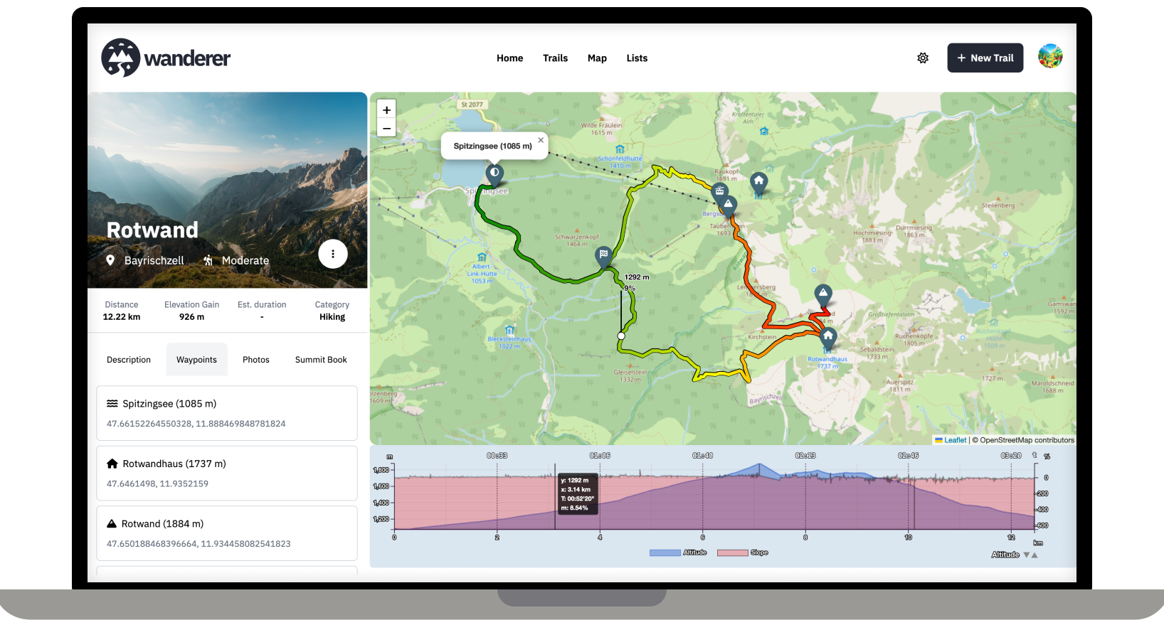
Over the last two months, I developed wanderer. It is a self-hosted alternative to sites like alltrails.com or in other words a self-hosted trail database. It started out more as a small hobby project to teach myself some new technologies but in the end, I decided to develop it into a fully-fledged application.
Core Features:
- Manage your trails
- Extensive map integration and visualization
- Share trails with other people and explore theirs
- Advanced filter and search functionality
- Create custom lists to organize your trails further
- Chique design with a dark and light theme
- Fully mobile compatible
wanderer is completely open-source. You can find the GitHub repo here: https://github.com/Flomp/wanderer
wanderer is still under active development so if you encounter any bugs/errors or have suggestions please let me know here or open an issue on GitHub.
You must log in or register to comment.
Question: why would I want to self-host this to use while I’m in the woods with no service, as opposed to an app on my device?
I think you might misunderstand what wanderer does. It is not a maps service like Open Street Maps. It’s simply a database in which you can store your GPS tracks. So the workflow would look like this: you are in the woods and record your track (e.g. with osmand) -> you store your track in GPX format -> you upload your track (and any additional info like a description or photos) to wanderer -> before your next adventure you check wanderer to decide what you want to do
I have some tracks from dirt biking that I sometimes port into Google earth. Might have to give this thing a whirl.
An after action report, basically?
You compared the service to AllTrails, which is a trail exploration and planning app. Like, walk down the trail and follow the map for navigation.
Can you log your trips without an active data connection?
Logging trips offline requires background location services. This does not work for a simple website. You would need to program an app for that. While this is a plan somewhere down the line, it’s still far away. So currently I would recommend relying on an external app to log your trip and import afterwards.
To plan, organize or review routes.
This seems more like Garmin Basecamp, it’s not supposed to be used on the routes themselves I’m guessing.
So you plan a route and then leave the plan at home and wing it?
Offering print support for trails is high on the priority list.
Very interesting, I like the screenshots! Will definitely check this out.
Amazing!
Welcome to Lemmy! I recently posted about Wanderer also in another self-hosting community: https://slrpnk.net/post/7887187
As someone interested in self-hosting this, I have two questions:
How far is it suitable for say a local hiking association or a small municipal government to use this as a public trail database to promote regional eco-tourism efforts? Where I live the local government has something like that, but it is badly maintained. For that to work it would need to have the ability to easily find trails on an overview map and to allow posting notices about trail closures etc. (ideally even crowd sourced?) Maybe also some way to mark trails as official, if they are designated and sign-posted.
Unrelated: have you thought about allowing the live-tracking via apps like Phonetrack or OSMand? I think that would make it both more convenient for uploading tracks (at least where there is sufficient cell-coverage) and might add an interesting social aspect to it if you can share your live-location with other users.
P.S.: Would be great if you could add it to https://translate.codeberg.org/ for adding additional languages easily.
Thanks for promoting wanderer! Finding trails on the map should be no problem, you can currently mark trails as public so that not logged-in users can see the trail. I have thought of steering wanderer towards a more socially interactive platform. I think a good first step would be to allow comments and implement a rating system.
Thanks for the crowdsourced translation website. I was looking for something like this. I will set it up and add it to the contributing section of the documentation.
I actually use Nextcloud
How do I change port to something else? 3000 is already used by Gitea :)
No that port is used by Homepage. B)
Come on man.
With docker you can simply change the port mapping in the compose file
I’ve done that, all containers report healthy, but still can’t connect. I’ve tried changing ORIGIN to ip;port, domain: port, still nothing. Really weird.
I tried Wanderer few days ago and I did find it very nice, yet quite buggy.
I was forced to update the page a second time before being able to do something, for an example using the menu.
But other than that, I find Wanderer very nice! Just miss seeing mainly how fast I was travelled in km/h. The statistics and details provided in workout-tracker1 is absolutely amazing! If you add such details into your project, that would be awesome!
Speed statistics were added in v0.2.0. Hopefully also with some bugfixes.
Very nice :) Me like! But the bug is still there when you have clicked on a trail on the home page. The page just scrolls up to the top and you have to update the page to see the trail.
That’s strange, I never had that happen. If you have the time could you please open an issue on GitHub?
I LOVE THIS.
Self hosted, GOOD LOOKING (rarity in FOSS), nice to use and privacy-aiding.
Thank you so much!
This is an excellent use case for a self hosted service, since location data is frequently used for nefarious purposes.
Super cool thank you for making this! I just got a bike for the first time in over 20 years and I’m ready to explore my area. I have been trying out those other apps like all trails and trail forks, everything being so paywalled is frustrating.
The bike I just got, it’s a beaut. A Clem Smith Jr. L from Rivendell Bike Works. I’m loving just scoping out parts and things but it’s a super great bike already.
I look forward to trying this out and thanks again!
Nice ! You made me think of spinning up a little server. It’s been a while since I’ve dabbled in managing a server and not aure I have the time for that. But you made the chances if me going for it much higher.
Would a raspberry pi 4 be enough for running it ?
Absolutely. I have it running on a Pi 5 and that’s more than enough. You only need 1GB of RAM when first starting wanderer. After that it sits at around 100Mb.
This is very nice :) I was working on a proof of concept similar to this to have a quick search functionality for FrankenJura (german hiking database) but it was lost in a drawer due to lack of time 😁 Great work and thanks for sharing it :)
Happy to help. If you can get a dump of the database it should be quite easy to import it into wanderer via the API 👍
If I recall correctly, I couldn‘t find API endpoints back then and had to browse/prse the pges based on the regions and the links on the landing pages 😅
Love it.
I’ve been willing to learn more about programming with location/map data so definitely checking this out.
Are you looking for contributions or help on anything? I think I might at least look at providing a Dutch translation for the front-end if you’re accepting PRs.
Absolutely all help is welcome. Please check out the roadmap for my current plans. I’d be delighted if you could add your Dutch translation here: https://translate.codeberg.org/projects/wanderer/wanderer/nl/
Dank je wel!
Wow. I aspire to be as knowledgeable as you one day. This motivated me.
This is ripe for multiuser and federation


