

Today I found out that it’s actually a lot easier to contribute to Open Street Map than I thought. There are some serious gaps in house addresses in my area and I was painstakingly using the built in browser editor in the browser.
But, you can use a FOSS app (available on fdroid) called StreetComplete that makes it a lot easier to help out filling in the gaps in your local map data.
It’s really fun - kind of like Pokémon Go but you are actually making an impact 😁
I didn´t realize editing OSM is so easy. I just logged in, did a short tutorial and fixed one intersection where a week ago the app told to do an illegal turn. Awesome!
deleted by creator
If push comes to shove, you can always create a note over the same place and mention “sorry I effed up here but don’t know how to revert :(”
I just installed StreetComplete because of your post and it’s a lot of fun! I guess I’ll be doing this on my walks from now on :-)
Hmm. I dislike that it uploads every thing as a separate change. I much more prefer editing the whole area and saving it as one neat package, rather than posting hundreds of “this is road is made of asphalt” posts.
So it’s not for me, but if that helps to make OSM better, I’m all for it!
Maybe I could make a separate account without neat history and from time to time click some icons in the app though. That probably wouldn’t bother me as much.
It actually bundles answers to a certain quest together if I remember correctly. For example, all road surface quests within a certain time (about an hour?) are grouped into one change set. Though if you did one road surface quests and one opening hours quests they would uploaded as two separate change sets.
You can do all of that with this
I can confirm that it works even if you only provide it with internet access periodically (e.g. on a wifi-only device).
it doesnt close a changeset after every single change, at least it shouldnt. mmv but if I close the app for some time it bundles my changes in one OSM set
No it doesn’t close changeset on every change, 30 days ago I added 123 house numbers in my city with streetcomplete and all of them were in the same changeset.
Do you need an account?
A OSM account, yes. You can join with OpenID if you want.
To contribute changes, yes. You still can share information as an anonymous user with OSM Notes, but then you need to be clear and a bit exhaustive. You can add a note that says “7-eleven” and a mapper can easily add it later, but for a restaurant called “The Coast”, for example, you need to explicitly write in the note that it is a restaurant serving seafood, details of the address and opening hours would be great too.
yes, afaik
As far as I am aware, yes.
I use Organic maps, and it’s easy to add and edit places with.
MapComplete is more about tagging.
Is there an open street map based map app that shows live traffic? I’m trying to get my grandfather to switch to open source, and he says it’s the one feature he needs.
No, unfortunately not. Getting traffic data would mean users volunteering to share location data, would need a centralized system to process everything, and would need a critical mass of users sharing said data to be anywhere near useful. The other possibility would be to pay for data from a provider like Google under an enterprise license that doesn’t require sharing data back, but I don’t know if that is even an option.
For now, I use both on my phone. I use OSM when biking or walking, I use Google Maps when driving, and I use my local transit web app when taking transit. I plan to switch my Pixel phone to GrapheneOS and to sandbox Google services that I still need. That being said, the ultimate way around needing traffic information is to try to live in places and in such a way that driving is not very necessary, but I know that is a huge ask for a lot of people.
EDIT: To be clear, MagicEarth does have live traffic as @[email protected] pointed out and is based on OSM, but is not itself open source.
time for some kind of anonymizing location data sharing service, peer to peer or federated protocol? that might be interesting, or sketchy, not sure which.
There is OpenTraffic but it seems unfinished and not implemented anywhere as far as i can tell. Edit: just to clarify, ive only heard from others that it’s unfinished, havent checked myself :)
That’s a super interesting project. For anyone else, the project overview has some great system level diagrams:
https://github.com/opentraffic/otv2-platform
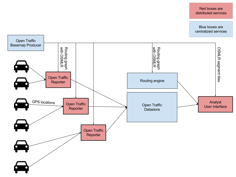
It looks really interesting - but unfortunately it seems it’s abandoned? Last time it was updated was 7 years ago…
OSMand has a feature where it can process other info as tiles on top of the base openstreetmap data it downloads, so what I did was pulling satellite and live traffic data from google and make them work as tiles and it works perfect (although it doesnt take traffic data into consideration when routing, it only shows it as a picture on top of the map, doesn’t bother me).
MagicEarth has got a live traffic layer for you.
If it is free as in beer, but not as in freedom, and is developed by a company, then what is their business model?
This is what they’ve put on their FAQ
Magic Earth is free for all our end-users but we also have a paid Magic Earth SDK for business partners. For instance Selectric.de (a supplier for navigation solutions for ambulances and fire trucks), Smarter AI (developing ADAS systems) or Absolute Cycling (using the platform on bicycles). For more info on the SDK, you can check magiclane.com.
That explains it, thanks
Magic earth is great
Unfortunately, it’s not open source though.
Indeed it isn’t. But is privacy focused and sort of the best next thing.
Yeah, I was just pointing it out for transparency, as this is the OSS community. Still a noteworthy app, though.
I’m addicted to Streetcomplete. I’m 20.000+ edits in. I make about 100 with ease on my commute to work.
It needs an iOS app
@gonzoknowsdotcom1 This app doesn’t seem quite as entertaining as #StreetComplete, but it is also available for #iOS: #EveryDoor
“#OpenStreetMap editor for POIs and entrances.”
every-door.app/
Furthermore, it is also very easy to edit #OSM data with #OrganicMaps: organicmaps.app/de/
@Schlemmy@caos @Schlemmy @gonzoknowsdotcom1 #EveryDoor is great, I use it alongside #StreetComplete as it has more attributes that can be set. First StreetComplete until no tasks are left, then EveryDoor for more details.
agreed
deleted by creator
vote and comment here https://github.com/streetcomplete/StreetComplete/discussions/5230
Check out Go Map!!, it’s also open source and has a similar feature to StreetComplete with its quests, at least from what I’ve heard about how StreetComplete works.
iOS apps generally require a $100 yearly fee to post to the app store and if they submitted a waiver as a nonprofit apple would probably take years to accept it.
Also apple has a tendency to quietly kill and/or stall small apps that pose a threat to features they incorporate into their os from what I’ve heard.
Donations
Ugh yeah the small 4-person worker cooperative I’m part of has been trying to get Apple to let us enroll in their developer program for literally weeks now. Every time we clear some other nonsense requirement, there’s a new one right behind it; and we haven’t even gotten to the “pay $100 for the privilege of undergoing this process” part yet.
I can’t believe Apple ever managed to build an application ecosystem around their products when they are so unfriendly to developers.
What? If you’re going to pay for it you just sign up and pay… If you don’t have your company registered before attempting that that’s on you. And if you’re really desperate you could just use a personal developer account which you can set up in like 1 minute. Not sure how this is an issue for you.
once you complete every quest on your commute, what do you do?
parallel streets ✅
and then?
Not parallel streets.
that turns the commute into a promenade
That’s exactly what happened. Fortunately I have 4 different offices and I can work from ‘home’ anywhere so sometimes I go work at a friend’s place instead of working at my place.
There’s always more to tag. It’s crazy. But I started talking walks during my break.
One thing that I haven’t got to is tagging street width and that you can do by using your phones’ camera for measuring.
https://apt.izzysoft.de/fdroid/index/apk/de.westnordost.streetmeasure
In order to use this app, you will need to have the proprietary Google Play Services for AR app installed on your device as well.🤐
edit: this is for StreetMeasure
_What are the system requirements of this app?
StreetComplete requires Android 5.0, and a screen size of at least 4.3" is recommend. Apart from that, any reasonably modern phone (at least 2GB RAM, around 500MB of free space) should support it. It doesn’t require Google Play Services_
Edit: You were aiming at Streetcomplete, I see now. This is in their FAQ:
According to our tests, it does work without Google Play Services being installed, but, as said before, the device needs to be compatible.
i’m using streetComplete without google. It’s streetMeasure that requires Google Play Sevices
Apparently, per their own FAQ, it is possible to use it without Google Play Services.
_What are the system requirements of this app?
StreetComplete requires Android 5.0, and a screen size of at least 4.3" is recommend. Apart from that, any reasonably modern phone (at least 2GB RAM, around 500MB of free space) should support it. It doesn’t require Google Play Services_
You are a hero
Cool! Never seen this before. Just downloaded and signed up.
I installed it. Judging by the mass of blank info, I guess I’m the only person around here using it lol. 😳
I became nr 10 or so in my country just by adding nearly everything SC can ask in … a 10 block radius around my house.😁
I am never getting lost in my own neighborhood again!! (Me irl)
It seems like a very helpful service. I don’t use cell data which means no GPS to contribute to it. I only use apps through wi-fi exclusively.
Pretty sure you can download the maps ahead of time, GPS doesn’t require data, then upload the fixes when you get home.
This is what I do, works great
does it need cell-data? why? that surprises me; but then again maybe not . . .
Nope, doesn’t need cell data
It does not.
I’m still missing this on iOS, we do have “go map!!” Which is great, but that’s a bit of a different kind of app for me.
i use Every Door on ios… its UI is hideous, but very functional
in still pretty new to it all though so it might not be great… better than go map for edits though
deleted by creator
Go map keeps crashing for me, does it for you?
deleted by creator
That was my thinking. The OSM is only as good as we make it so the more people know how to fix it, the better for the community 😉
deleted by creator
I’ve been using Go Map! but it keeps crashing… Maybe I’ll try Streetcomplete if it’s on apple.
Another recommendation, especially for addresses and points of interest, is https://every-door.app/
It’s not as pretty as StreetConplete but it’s fine to work with.
Solid recommendation! “Contribute missing data” sounds like a chore, but this app is super fun